

A view across a portion of the site proposed for a housing estate if council approves a variation of the new Ipswich Planning Scheme. The photo appears in the application from developer, Turnbull Road Holdings Pty Ltd.
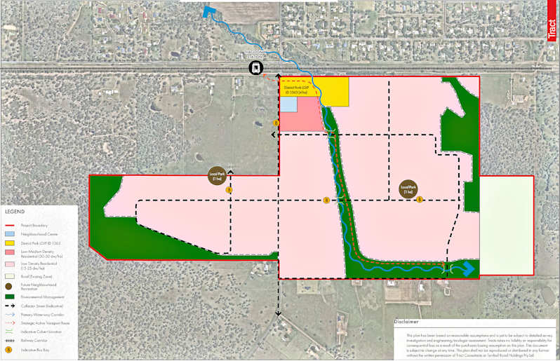
A diagram accompanying the application using colour coding to show the estimated boundaries of the various proposed land uses - blue: neighbourhood shopping centre; yellow: district park; dark pink: low to medium density housing (30-50 homes per hectare); light pink: low density residential; light cream: rural; dark brown: neighbourhood recreation area; green environmental management areas.

The 12 properties (indicated by red boundary lines) with addresses on McGearys Road, Kavanagh Road East, Turnbull Road and Kavanagh Road, which make up the proposed development area. The property at far right is the one where the developer plans to retain the rural zoning. While 11 of the properties are similar in size, the 12th and much smaller one can be seen nearest the symbol for the Thagoona Railway Station.
A CLUSTER of 12 properties covering 155 hectares south of the rail line at Thagoona could become the next mega residential estate in the western corridor if the developer can first overcome some hurdles.
The most significant hurdle is that the farmland properties are zoned rural.
The rural zoning may be less of a hurdle than it would seem.
Developer, Turnbull Road Holdings Pty Ltd, points out in the application to the Ipswich City Council that while the local planning scheme zones the land as rural, under the SEQ Regional Plan, 11 of the properties are within an area designated as ‘urban footprint’.
Plans for the easternmost property are for it to remain rural and become an environmental management zone for use as green space serving the potential residents of the proposed estate.
The detail on the future swathe of residential subdivisions across the other properties is sketchy other than to note that the first will be of 120 allotments.
Adding a little more detail, according to the application, the developer plans to initially bring the allotments in the proposed low density zone to market (15 to 25 dwellings per hectare) before developing the land closer to the rail line within the proposed low-medium zone (30 to 40 dwellings per hectare).
It is also noted that while the Walloon - Thagoona area currently has a population of around 3,500, council expects the population to increase to 50,000 over the next 20 years.
The developer has dubbed the proposal for the housing estate as Thagoona South Precinct and outlines the outcomes of pre-application discussions with the council and the state government.
Of the discussions with council: “The Applicant has worked with Council, including in formal pre-lodgement meetings and ongoing consultation, regarding key parameters and design constraints for the site” … and has tailored the application documents accordingly.
Of the discussions with the state government: “The Applicant has engaged with the ShapingSEQ review team to discuss the Thagoona South Precinct at length, up to the area’s inclusion in the Urban Footprint in 2023.
“Further, a formal pre-lodgement meeting was held with SARA in 2025 specifically in relation to the site, and the following key matters were discussed:
• Traffic, stormwater and flooding impacts on the state-controlled road network;
• Public passenger transport and active transport;
• Railway level crossing safety;
• Native vegetation clearing;
• Waterway barrier works; and
• Koala habitat.
“The proposal has considered the relevant comments from the State and addressed the relevant matters within the material submitted as part of the development application.”
The application last week represents the first step towards residential development. The developer is seeking a variation to the new Ipswich Planning Scheme to enable the rezoning of the land.
It is an ‘impact assessible’ application which means that the developer will need to advertise for public submissions during the application process.


